Tuesday, February 26, 2013

Today, we had complete cloud cover for much of the day. wind was coming from the NE between 15 and 20 mph in the afternoon. During the evening, the wind calmed down to between 5 and 8 mph, still coming from the NE. The high for today was around 38 F.

The low pressure system that has been moving through the central US can be seen in the surface data map below. It is now just SE of the Chicago area.
 Both the surface data map above and the current surface map below show that portions of the Midwest where the low is located are experiencing light continuous snow or rain. The map below shows an occluded front, which indicates that the system has weakened.

Monday, February 11, 2013

Today was a fairly calm overcast day. There was 10 to 15mph WNW winds with up to 20mph gusts. Temperatures got up to about 30F. There were some flurries off and on through out the day as well.

Below is an image I put together showing the weather around the Great Lakes from this evening. The arrows indicate the direction and speed of wind - the shortest arrows represent 5mph winds while the longest arrows represent 25mph winds. The snowflakes represent light snow and the clouds represent overcast skies. By looking at the wind pattern, you can kind of make out where the low pressure system that just passed through this weekend is located.

According to noaa.gov, the current barometric reading is 1016.7 mb. Below is a diagram of the barometric pressure throughout the day from UW - Eau Claire's weather page. The trend shown can be associated with the low pressure system moving out and a high pressure system coming in. Based off of that, we should see some sunny skies for tomorrow, perhaps in the afternoon.
Daily Barometer Graph

The image below is from intellicast.com. It shows the predicted jetstream for tomorrow. What is very noticeable about the jetstream is a prominent trough in the central U.S. and the southern Rockies. Associated with the trough are calmer winds and cooler temperatures. Moving west or east away from the trough, temperatures and wind speeds increase. You will also notice a trough in the northwestern part of the map and a broad ridge in the southwest.

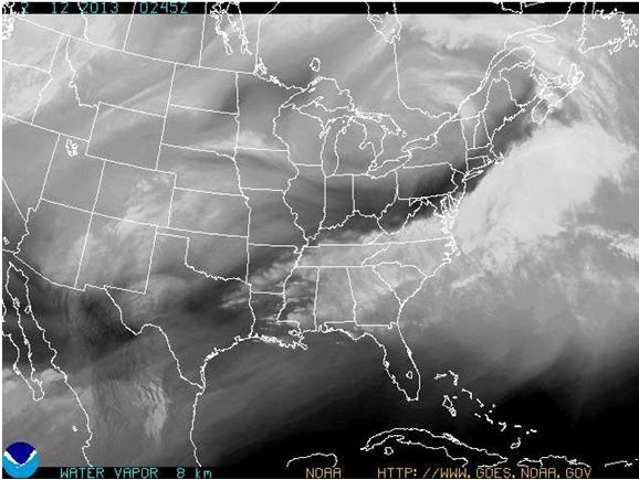
Below is an image from noaa.gov of watervapor. In this image you will notice on the east coast a distinct line between where there is little watervapor and where there is more concentrated watervapor. This is associated with the low pressure system, or nor'easter, that just dumped around 30 inches of snow in some areas of New York and Massachusetts.

And judging by the diagram from below from accuweather.com, it is predicted another low pressure system will produce more storms for the east coast by this weekend, as part of the end of February's string of storms. Because this same low pressure system will be passing through Eau Claire, we should expect to see some precipitation sometime between wednesday night and friday morning.


Thursday, February 7, 2013

There was complete cloud cover all day yesterday along with a 10 mph East wind. In the afternoon, the temperature was about 20 degrees. From 12 pm to about 2 pm, it snowed with an accumulation of about an inch and a half. During the evening the temperature rose to around 29 degrees by 10pm.

Below is a picture I took yesterday while walking to class in the snow.


Tuesday, February 5, 2013

Yesterday's weather was much like the last few days. The day started out sunny with little to no wind. During the afternoon, skies were mostly cloudy with about a 5 mph wind coming from the NW and a high of around 10 degrees. Overnight, there was complete cloud cover accompanied by a light dusting of snow.

Friday, February 1, 2013

First Weather Post

Today was even colder than yesterday with a high of maybe 3 degrees. Earlier in the day, there wasn't a cloud in the sky. While walking to class just past noon I noticed there was maybe a 5 mph wind coming from the WSW. By about 4 in the afternoon, the wind had completely died out and the skies were mostly cloudy. Whether or not these clouds mean some precipitation at some point during the weekend, I'm not sure.

The cold we've been experiencing the last couple of days comes after some odd weather that seems to be almost typical of late January weather in Wisconsin. Sunday afternoon and evening, we got a little over an inch of sleet, rain and snow. Late Monday night, it literally poured, which led to classes being postponed until 9:30 Tuesday morning.