Last night, a low pressure system, winter storm triton, came through southwestern and central Wisconsin dumping around 4-5 inches here in Eau Claire. The diagram below shows current conditions as of 1:00 am this morning

The two infrared diagrams below show the moisture associated with this storm. And as you can see, Triton was carrying quite a bit of moisture.


The surface data map below shows conditions from 1am this morning as well. The barometric pressure for Eau Claire at that time was 980 mbar and 975 mbar for La Crosse.

The image below is The Weather Channel's prediction of Triton's path through Tuesday. According to their diagram, Eau Claire was to recieve 3-5 inches of snow, which was fairly accurate. One thing to note is the band of heavier snow in the diagram. I don't much about lake effect snow, but this may be due the storm picking up moisture from the Great Lakes and due to the counter-clockwise rotation of the system, dumps that extra moisture on the U.P.

Through out the day today there were off and on snow flurries that didn't amount to any accumulation. The high for the day was around 31F with winds reaching 15mph coming from the northwest.

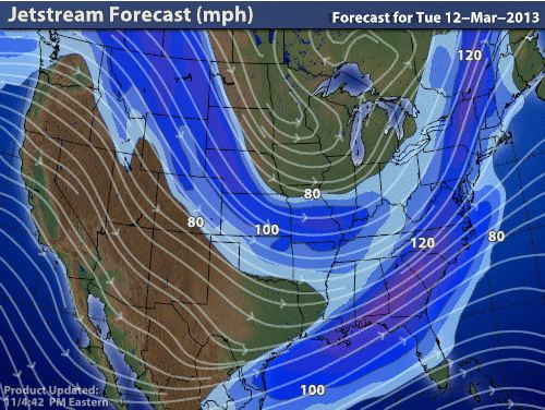
The surface map to the right shows where the low associated with Triton is and the diagram below that also shows how the low is affecting the jetstream.

The Weather Channel is also expecting the jetstream to 'flatten out' after Triton has moved through. This flattening of the jetstream could mean that the next few storms to come through should stay more to the north, and perhaps travel through more of southern Canada. Along with that flattening out, there will be a trough in the jetstream over the great lakes and the northeast that will bring cooler weather. As for much of the southern states, they should be expecting warmer than usual temperatures come the weekend.

No comments:
Post a Comment